Geolocate

Lovera topographic map

Click on the map to display elevation.

About this map

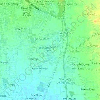
Name: Lovera topographic map, elevation, terrain.

Location: Lovera, Ica, 11004, Perú (-14.12302 -75.74370 -14.08302 -75.70370)

Average elevation: 398 m

Minimum elevation: 388 m

Maximum elevation: 417 m

Other topographic maps

Click on a map to view its topography, its elevation and its terrain.

Huacachina

Perú > Ica > Ica > Huacachina

Average elevation: 439 m

Plaza de Armas de Ica

Perú > Ica > Ica

Average elevation: 409 m

Parque del Amor

Perú > Ica > Ica

Average elevation: 408 m

Huacachina

Perú > Ica > Ica > Huacachina

Average elevation: 439 m

Cachiche

Perú > Ica > Ica

Average elevation: 398 m

Plaza de Armas de Ica

Perú > Ica > Ica

Average elevation: 409 m

Gear up for your next adventure:

Lightweight Camping Tent - Portable shelter optimized for Canadian backcountry camping
🥾All-Terrain Hiking Boots - Versatile boots for varied hiking conditions
🧥Ultralight Puffy Jacket - Maximum warmth that packs down to the size of an orange
🔭Compact Binoculars - Lightweight optics for scouting trails and wildlife
🦶Hiking Shoe Insoles - Added support for high arches and long days on feet

As an Amazon Associate, this site earns from qualifying purchases at no extra cost to you.