
Kirkby Mallory topographic map
Click on the map to display elevation.
About this map
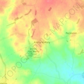
Name: Kirkby Mallory topographic map, elevation, terrain.
Average elevation: 115 m
Minimum elevation: 83 m
Maximum elevation: 143 m
Other topographic maps
Click on a map to view its topography, its elevation and its terrain.
Burbage
United Kingdom > England > Leicestershire > Hinckley and Bosworth > Stretton Baskerville
Average elevation: 110 m
Market Bosworth Country Park
United Kingdom > England > Leicestershire > Hinckley and Bosworth > Market Bosworth
Average elevation: 119 m
Markfield
United Kingdom > England > Leicestershire > Hinckley and Bosworth > Markfield
Average elevation: 174 m
Groby
United Kingdom > England > Leicestershire > Hinckley and Bosworth > Groby
Average elevation: 107 m
Desford
United Kingdom > England > Leicestershire > Hinckley and Bosworth > Botcheston
Average elevation: 115 m
Newbold Verdon
United Kingdom > England > Leicestershire > Hinckley and Bosworth
Average elevation: 129 m
Market Bosworth
United Kingdom > England > Leicestershire > Hinckley and Bosworth
Average elevation: 103 m
Billa Barra Hill
United Kingdom > England > Leicestershire > Hinckley and Bosworth > Stanton under Bardon
Average elevation: 191 m
Stoke Golding
United Kingdom > England > Leicestershire > Hinckley and Bosworth
Average elevation: 102 m
Thornton Reservoir
United Kingdom > England > Leicestershire > Hinckley and Bosworth > Thornton
Average elevation: 139 m
Earl Shilton
United Kingdom > England > Leicestershire > Hinckley and Bosworth
Average elevation: 101 m
Higham on the Hill
United Kingdom > England > Leicestershire > Hinckley and Bosworth
Average elevation: 94 m
Shackerstone
United Kingdom > England > Leicestershire > Hinckley and Bosworth
Average elevation: 104 m
Bagworth Heath Woods
United Kingdom > England > Leicestershire > Hinckley and Bosworth > Thornton
Average elevation: 138 m
Burroughs Wood
United Kingdom > England > Leicestershire > Hinckley and Bosworth > Botcheston
Average elevation: 114 m
Earl Shilton
United Kingdom > England > Leicestershire > Hinckley and Bosworth
Average elevation: 101 m
Stanton-under-Bardon
United Kingdom > England > Leicestershire > Hinckley and Bosworth
Average elevation: 171 m