Geolocate

Lucerne topographic map

Click on the map to display elevation.

About this map

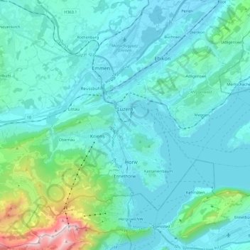
Name: Lucerne topographic map, elevation, terrain.

Location: Lucerne, Switzerland (46.99801 8.20651 47.08352 8.42798)

Average elevation: 630 m

Minimum elevation: 410 m

Maximum elevation: 2,113 m

Other topographic maps

Click on a map to view its topography, its elevation and its terrain.

Hämikon

Switzerland > Lucerne

Average elevation: 671 m

Alpach

Switzerland > Lucerne > Escholzmatt-Marbach > Escholzmatt

Average elevation: 966 m

Hellbühl

Switzerland > Lucerne

Average elevation: 639 m

Gunzwil

Switzerland > Lucerne

Average elevation: 671 m

Schiltalp

Switzerland > Lucerne > Kriens

Average elevation: 962 m

Allmendhubel

Switzerland > Lucerne > Menznau

Average elevation: 636 m

Schloss Meggenhorn

Switzerland > Lucerne > Meggen

Average elevation: 450 m

Sörenberg

Switzerland > Lucerne

Average elevation: 1,386 m

Marbachegg

Switzerland > Lucerne > Escholzmatt-Marbach

Average elevation: 1,159 m

Schachen

Switzerland > Lucerne > Werthenstein > Schachen

Average elevation: 671 m

Gear up for your next adventure:

🔪Outdoor Multitool - Versatile tool for repairs and food prep in the wild
💧Hydration Bladder - Hands-free hydration solution for long treks
🏃Hydration Running Vest - Carry water and maps close to your body for speed
🦶Hiking Shoe Insoles - Added support for high arches and long days on feet
💡LED Camping Lantern - Illuminate your campsite with long-lasting lanterns

As an Amazon Associate, this site earns from qualifying purchases at no extra cost to you.