Geolocate

New Lenox topographic map

Interactive map

Click on the map to display elevation.

About this map

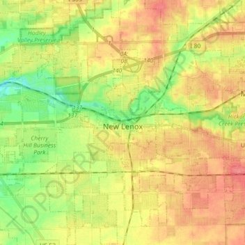
Name: New Lenox topographic map, elevation, terrain.

Location: New Lenox, Will County, Illinois, 60451, United States (41.46077 -88.02610 41.56651 -87.90743)

Average elevation: 209 m

Minimum elevation: 177 m

Maximum elevation: 237 m

Other topographic maps

Click on a map to view its topography, its elevation and its terrain.

Frankfort

United States > Illinois > Will County > Frankfort

Average elevation: 225 m

Wilmington

United States > Illinois > Will County > Wilmington

Average elevation: 175 m

Joliet

United States > Illinois > Will County

Average elevation: 195 m

Plainfield

United States > Illinois > Will County

Like its namesake, Plainfield's topography is generally flat. Thousands of years ago, land in greater Plainfield used to be part of the bed of proglacial Lake Wauponsee. However, the lake did not hold up long, and eventually drained into the Illinois River valley.[13] The lake left behind a very flat…

Average elevation: 194 m