
Roanoke topographic map
Click on the map to display elevation.
About this map
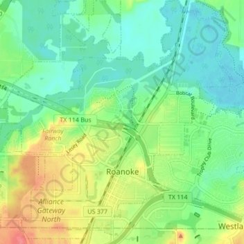
Name: Roanoke topographic map, elevation, terrain.
Location: Roanoke, Denton County, Texas, 76262, United States (32.98695 -97.25795 33.04407 -97.19552)
Average elevation: 186 m
Minimum elevation: 164 m
Maximum elevation: 226 m
Other topographic maps
Click on a map to view its topography, its elevation and its terrain.
Clear Creek Natural Heritage Center
United States > Texas > Denton County > Denton
Average elevation: 173 m
Lakewood Village
United States > Texas > Denton County > Lakewood Village > Lakewood Village
Average elevation: 163 m
Lewisville
United States > Texas > Denton County > Lewisville
Lewisville is at 33°2′18″N 97°0′22″W / 33.03833°N 97.00611°W / 33.03833; -97.00611 (33.038316, −97.006232) at an elevation of about 550 feet (170 m). It has a total area of 42.47 square miles (110.0 km2), of which 36.4 sq mi (94 km2) is land. It lies at the southern end of Denton County…
Average elevation: 174 m