
بلدية نمار topographic map
Interactive map
Click on the map to display elevation.
About this map
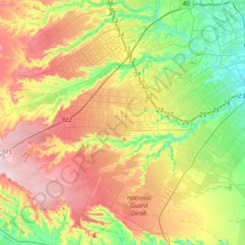
Name: بلدية نمار topographic map, elevation, terrain.
Location: بلدية نمار, محافظة الرياض, Riyad, 14928, Arabie saoudite (24.50297 46.44218 24.61650 46.70523)
Average elevation: 725 m
Minimum elevation: 578 m
Maximum elevation: 916 m
Other topographic maps
Click on a map to view its topography, its elevation and its terrain.
بلدية النسيم
بلدية النسيم, محافظة الرياض, Riyad, Arabie saoudite
Average elevation: 624 m
Al Urayja
Al Urayja, محافظة الرياض, Riyad, Arabie saoudite
Average elevation: 692 m
بلدية السلي
بلدية السلي, محافظة الرياض, Riyad, Arabie saoudite
Average elevation: 587 m
Al Malazz
Al Malazz, بلدية الملز, محافظة الرياض, Riyad, 12836, Arabie saoudite
Average elevation: 598 m
Riyad
Riyad, Al Malaz, محافظة الرياض, Riyad, 11131, Arabie saoudite
Average elevation: 630 m