Geolocate

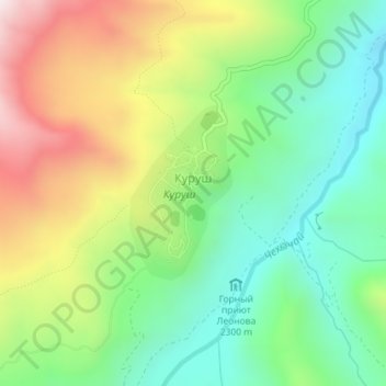
Kurush topographic map

Click on the map to display elevation.

Kurush

Kurush (Russian: Куруш; Lezgian: Къуруш) is a mountain village located in the Dokuzparinsky District, in southern Dagestan. Situated at 2480–2560 m above sea level depending on the source (topographical maps show the center at about 2530 m), it is the highest continuously inhabited settlement of the Greater Caucasus and of Europe as well as the southernmost settlement in Russia. As of 2015, Kurush had a population of 813.

Wikipedia (CC-BY-SA 3.0)

About this map

Name: Kurush topographic map, elevation, terrain.

Location: Kurush, сельское поселение Село Куруш, Dokuzparinsky District, Dagestan, North Caucasian Federal District, 368754, Russia (41.27584 47.82806 41.28812 47.83767)

Average elevation: 2,495 m

Minimum elevation: 2,207 m

Maximum elevation: 2,952 m

Gear up for your next adventure:

⛺Camping Tent - Weather-resistant tents suitable for 2 to 6 people
🧭GPS Tracker - Track your location in remote areas safely
🥾Trekking Poles - Adjustable trekking poles to reduce knee stress and improve stability
🎒Fully Waterproof Backpack - Total protection for photography gear and electronics
🥾Trekking Boots - Durable boots for long-distance trekking

As an Amazon Associate, this site earns from qualifying purchases at no extra cost to you.