Geolocate

Grande Cache topographic map

Click on the map to display elevation.

About this map

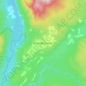
Name: Grande Cache topographic map, elevation, terrain.

Location: Grande Cache, Municipal District of Greenview, Alberta, T0E 0Y0, Canada (53.84881 -119.15857 53.92881 -119.07857)

Average elevation: 1,195 m

Minimum elevation: 940 m

Maximum elevation: 1,912 m

Alberta trails, hiking, mountain biking, running and outdoor activities

Gear up for your next adventure:

🥾Approach Boots - Comfortable boots for hiking and climbing approaches
🕶️Polarized Sunglasses - Reduces glare from snow and water at high elevations
🧥Ultralight Puffy Jacket - Maximum warmth that packs down to the size of an orange
🧰Emergency Multi-Tool - Compact multi-tool for outdoor survival
🪑Ultralight Camping Stool - Compact seating for rest stops during long hikes

As an Amazon Associate, this site earns from qualifying purchases at no extra cost to you.