
Make a donation
Gear up for your next adventure:
As an Amazon Associate, this site earns from qualifying purchases at no extra cost to you.
Erksdorf topographic map
Click on the map to display elevation.
Make a donation
Gear up for your next adventure:
As an Amazon Associate, this site earns from qualifying purchases at no extra cost to you.
About this map
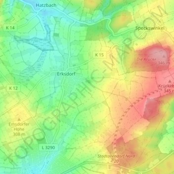
Name: Erksdorf topographic map, elevation, terrain.
Average elevation: 286 m
Minimum elevation: 241 m
Maximum elevation: 351 m
Make a donation
Gear up for your next adventure:
As an Amazon Associate, this site earns from qualifying purchases at no extra cost to you.
Other topographic maps
Click on a map to view its topography, its elevation and its terrain.
Neustadt (Hessen)
Deutschland > Hessen > Landkreis Marburg-Biedenkopf > Neustadt
Average elevation: 292 m
Wallau (Lahn)
Deutschland > Hessen > Landkreis Marburg-Biedenkopf > Biedenkopf > Wallau (Lahn)
Average elevation: 371 m
Make a donation
Gear up for your next adventure:
As an Amazon Associate, this site earns from qualifying purchases at no extra cost to you.
Rüchenbach
Deutschland > Hessen > Landkreis Marburg-Biedenkopf > Rüchenbach
Die Statistisch-topographisch-historische Beschreibung des Großherzogthums Hessen berichtet 1830 über Rüchenbach.
Average elevation: 280 m
Make a donation
Gear up for your next adventure:
As an Amazon Associate, this site earns from qualifying purchases at no extra cost to you.
Hinterstein
Deutschland > Hessen > Landkreis Marburg-Biedenkopf > Breidenbach
Average elevation: 367 m
Bracht-Siedlung
Deutschland > Hessen > Landkreis Marburg-Biedenkopf > Rauschenberg
Average elevation: 290 m
Hartenrod
Deutschland > Hessen > Landkreis Marburg-Biedenkopf > Bad Endbach
Die Statistisch-topographisch-historische Beschreibung des Großherzogthums Hessen berichtet 1830 über Hartenrod.
Average elevation: 422 m
Make a donation
Gear up for your next adventure:
As an Amazon Associate, this site earns from qualifying purchases at no extra cost to you.
Günterod
Deutschland > Hessen > Landkreis Marburg-Biedenkopf > Bad Endbach
Kreuzungspunkt alter Höhenwege mit Turmburg
Average elevation: 396 m
Am Kleeberg
Deutschland > Hessen > Landkreis Marburg-Biedenkopf > Biedenkopf > Ludwigshütte
Average elevation: 359 m
Make a donation
Gear up for your next adventure:
As an Amazon Associate, this site earns from qualifying purchases at no extra cost to you.
Dilschhausen
Deutschland > Hessen > Landkreis Marburg-Biedenkopf > Marburg > Dilschhausen
Average elevation: 301 m
Niederwetter
Deutschland > Hessen > Landkreis Marburg-Biedenkopf > Wetter > Niederwetter
Average elevation: 235 m
Make a donation
Gear up for your next adventure:
As an Amazon Associate, this site earns from qualifying purchases at no extra cost to you.
Mellnauer Kreuz
Deutschland > Hessen > Landkreis Marburg-Biedenkopf > Wetter > Mellnau
Average elevation: 344 m
Make a donation
Gear up for your next adventure:
As an Amazon Associate, this site earns from qualifying purchases at no extra cost to you.