
Make a donation
Gear up for your next adventure:
As an Amazon Associate, this site earns from qualifying purchases at no extra cost to you.
Flur 3 topographic map
Click on the map to display elevation.
Make a donation
Gear up for your next adventure:
As an Amazon Associate, this site earns from qualifying purchases at no extra cost to you.
About this map
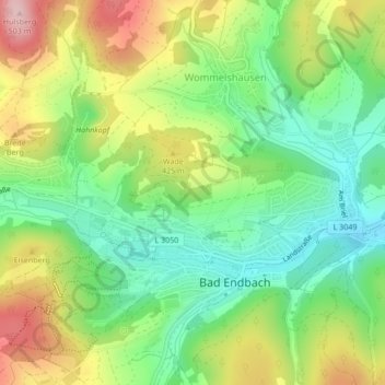
Name: Flur 3 topographic map, elevation, terrain.
Average elevation: 368 m
Minimum elevation: 278 m
Maximum elevation: 500 m
Make a donation
Gear up for your next adventure:
As an Amazon Associate, this site earns from qualifying purchases at no extra cost to you.
Other topographic maps
Click on a map to view its topography, its elevation and its terrain.
Bottenhorn
Deutschland > Hessen > Landkreis Marburg-Biedenkopf > Bad Endbach
Der Ortsteil Bottenhorn der Gemeinde Bad Endbach liegt im Gladenbacher Bergland (östlicher Ausläufer des Westerwaldes, der sich hier überschneidet mit dem Südausläufer des Rothaargebirges) in einer wechselhaften Mittelgebirgslandschaft, im Naturpark Lahn-Dill-Bergland, zwischen den Städten Marburg und…
Average elevation: 502 m