
Make a donation
Gear up for your next adventure:
As an Amazon Associate, this site earns from qualifying purchases at no extra cost to you.
Murr topographic map
Click on the map to display elevation.
Make a donation
Gear up for your next adventure:
As an Amazon Associate, this site earns from qualifying purchases at no extra cost to you.
Murr
Das Quellgebiet der Murr liegt 3 km südlich der Stadt Murrhardt auf den Höhen des Murrhardter Waldes. Am südlichen Ortsrand des Weilers Vorderwestermurr weist ein Schild einen gefassten Quelltopf als „Murrursprung“ aus. Wegen seines Wasserreichtums und seiner Beständigkeit lagerten in der Umgebung der Quelle bereits zur Steinzeit Menschen an Rastplätzen und Feuerstellen.
Make a donation
Gear up for your next adventure:
As an Amazon Associate, this site earns from qualifying purchases at no extra cost to you.
About this map
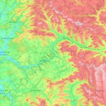
Name: Murr topographic map, elevation, terrain.
Location: Murr, Rems-Murr-Kreis, Baden-Württemberg, Deutschland (48.92989 9.25056 49.00143 9.63897)
Average elevation: 374 m
Minimum elevation: 200 m
Maximum elevation: 597 m
Make a donation
Gear up for your next adventure:
As an Amazon Associate, this site earns from qualifying purchases at no extra cost to you.
Other topographic maps
Click on a map to view its topography, its elevation and its terrain.
Kirchenkirnberg
Deutschland > Baden-Württemberg > Rems-Murr-Kreis > Murrhardt
Average elevation: 480 m
Stöckenhof
Deutschland > Baden-Württemberg > Rems-Murr-Kreis > Berglen > Öschelbronn
Average elevation: 362 m
Make a donation
Gear up for your next adventure:
As an Amazon Associate, this site earns from qualifying purchases at no extra cost to you.
Make a donation
Gear up for your next adventure:
As an Amazon Associate, this site earns from qualifying purchases at no extra cost to you.
Hertmannsweiler
Deutschland > Baden-Württemberg > Rems-Murr-Kreis > Winnenden > Hertmannsweiler
Average elevation: 329 m
Vordersteinenberg
Deutschland > Baden-Württemberg > Rems-Murr-Kreis > Alfdorf > Vordersteinenberg
Average elevation: 489 m
Zwingelhausen
Deutschland > Baden-Württemberg > Rems-Murr-Kreis > Kirchberg an der Murr
Average elevation: 302 m
Make a donation
Gear up for your next adventure:
As an Amazon Associate, this site earns from qualifying purchases at no extra cost to you.