
Kosi topographic map
Interactive map
Click on the map to display elevation.
About this map
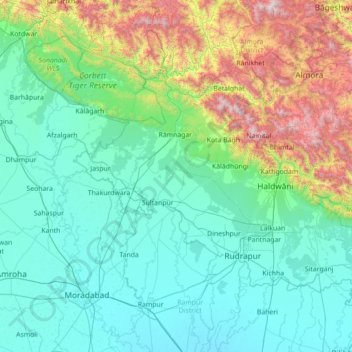
Name: Kosi topographic map, elevation, terrain.
Location: Kosi, Uttarakhand, India (28.63392 78.94703 29.86158 79.64754)
Average elevation: 603 m
Minimum elevation: 176 m
Maximum elevation: 2,681 m
Other topographic maps
Click on a map to view its topography, its elevation and its terrain.
Lachi
India > Uttarakhand > Thailisain > Matkunda > Lachi
Lachi, Matkunda, Thailisain, Pauri Garhwal, Uttarakhand, 246278, India
Average elevation: 1,507 m
Rajaji National Park
India > Uttarakhand > Totla
Rajaji National Park, Laxman Jhula, Pandav Gufa, Totla, Pauri Garhwal, Uttarakhand, 249304, India
Average elevation: 709 m