
Fernley topographic map
Click on the map to display elevation.
About this map
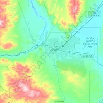
Name: Fernley topographic map, elevation, terrain.
Location: Fernley, Lyon County, Nevada, United States (39.45994 -119.32302 39.74054 -119.05858)
Average elevation: 1,458 m
Minimum elevation: 1,209 m
Maximum elevation: 2,237 m
Other topographic maps
Click on a map to view its topography, its elevation and its terrain.
Mason Valley Swimming Pool Park
United States > Nevada > Lyon County > Yerington
Average elevation: 1,336 m