
Make a donation
Gear up for your next adventure:
As an Amazon Associate, this site earns from qualifying purchases at no extra cost to you.
Lemoyne topographic map
Click on the map to display elevation.
Make a donation
Gear up for your next adventure:
As an Amazon Associate, this site earns from qualifying purchases at no extra cost to you.
About this map
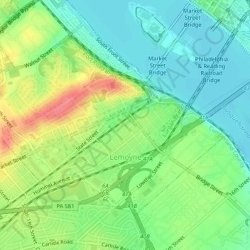
Name: Lemoyne topographic map, elevation, terrain.
Average elevation: 114 m
Minimum elevation: 87 m
Maximum elevation: 158 m
Make a donation
Gear up for your next adventure:
As an Amazon Associate, this site earns from qualifying purchases at no extra cost to you.
Other topographic maps
Click on a map to view its topography, its elevation and its terrain.
Carlisle Springs
United States > Pennsylvania > Cumberland County > Middlesex Township
Average elevation: 182 m
Lees Cross Roads
United States > Pennsylvania > Cumberland County > Southampton Township
Average elevation: 238 m
Pine Grove Furnace
United States > Pennsylvania > Cumberland County > Cooke Township
Average elevation: 332 m
Mount Zion
United States > Pennsylvania > Cumberland County > South Middleton Township
Average elevation: 179 m
Make a donation
Gear up for your next adventure:
As an Amazon Associate, this site earns from qualifying purchases at no extra cost to you.
Carlisle Springs
United States > Pennsylvania > Cumberland County > Middlesex Township
Average elevation: 182 m
Chestnut Crossroads
United States > Pennsylvania > Cumberland County > Southampton Township
Average elevation: 256 m
Green Spring
United States > Pennsylvania > Cumberland County > North Newton Township
Average elevation: 174 m
Treemont
United States > Pennsylvania > Cumberland County > East Pennsboro Township
Average elevation: 162 m
Make a donation
Gear up for your next adventure:
As an Amazon Associate, this site earns from qualifying purchases at no extra cost to you.
Caprivi
United States > Pennsylvania > Cumberland County > North Middleton Township
Average elevation: 156 m
Springville
United States > Pennsylvania > Cumberland County > South Middleton Township
Average elevation: 162 m
Liebys Trailer Park
United States > Pennsylvania > Cumberland County > Liebys Trailer Park
Average elevation: 138 m
Drexel Hills
United States > Pennsylvania > Cumberland County > New Cumberland
Average elevation: 111 m
Make a donation
Gear up for your next adventure:
As an Amazon Associate, this site earns from qualifying purchases at no extra cost to you.