
Make a donation
Gear up for your next adventure:
As an Amazon Associate, this site earns from qualifying purchases at no extra cost to you.
Château-Richer topographic map
Click on the map to display elevation.
Make a donation
Gear up for your next adventure:
As an Amazon Associate, this site earns from qualifying purchases at no extra cost to you.
About this map
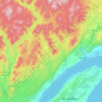
Name: Château-Richer topographic map, elevation, terrain.
Average elevation: 278 m
Minimum elevation: -3 m
Maximum elevation: 855 m
La Côte-de-Beaupré trails, hiking, mountain biking, running and outdoor activities
Make a donation
Gear up for your next adventure:
As an Amazon Associate, this site earns from qualifying purchases at no extra cost to you.
Other topographic maps
Click on a map to view its topography, its elevation and its terrain.
Forêt Montmorency
Canada > Quebec > La Côte-de-Beaupré > Lac-Jacques-Cartier
Located in the Laurentian Mountains, the Montmorency forest is drained by the Montmorency River and by one of its tributaries, the Black river. There are four lakes: Lac Piché, Bédard, Laflamme and Joncas. The altitude varies between 600 and 1,000 meters (3,300 ft) with an average of 750 meters. The…
Average elevation: 794 m
Make a donation
Gear up for your next adventure:
As an Amazon Associate, this site earns from qualifying purchases at no extra cost to you.
Make a donation
Gear up for your next adventure:
As an Amazon Associate, this site earns from qualifying purchases at no extra cost to you.
Mont Raoul-Blanchard
Canada > Quebec > La Côte-de-Beaupré > Lac-Jacques-Cartier
Average elevation: 982 m
Make a donation
Gear up for your next adventure:
As an Amazon Associate, this site earns from qualifying purchases at no extra cost to you.
Make a donation
Gear up for your next adventure:
As an Amazon Associate, this site earns from qualifying purchases at no extra cost to you.