Geolocate

Kindaruma topographic map

Click on the map to display elevation.

About this map

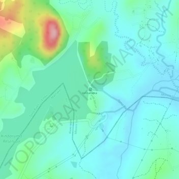
Name: Kindaruma topographic map, elevation, terrain.

Location: Kindaruma, Mbeere South, Embu, Eastern, Kenya (-0.80684 37.81062 -0.80570 37.81120)

Average elevation: 782 m

Minimum elevation: 741 m

Maximum elevation: 915 m

Other topographic maps

Click on a map to view its topography, its elevation and its terrain.

Mavuria

Kenya > Embu > Mbeere South

Average elevation: 1,061 m

Gachoka

Kenya > Embu > Mbeere South

Average elevation: 1,174 m

Kiritiri

Kenya > Embu > Mbeere South

Average elevation: 1,152 m

Gear up for your next adventure:

Camping Groundsheet - Protect your tent from moisture and dirt
🥾Trekking Boots - Durable boots for long-distance trekking
🧳Compression Sacks - Maximize space in your backpack by shrinking gear
🗺️Topographic Maps - Detailed maps to explore trails, mountains, and wilderness areas
🥾Mountain Trail Shoes - High-traction shoes for mountain trails

As an Amazon Associate, this site earns from qualifying purchases at no extra cost to you.