Geolocate

Forlì topographic map

Click on the map to display elevation.

About this map
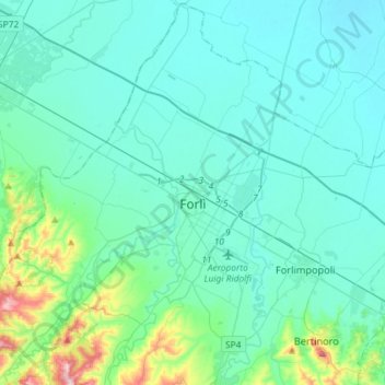
Name: Forlì topographic map, elevation, terrain.

Location: Forlì, Unione di Comuni della Romagna Forlivese, Forlì-Cesena, Emilia-Romagna, 47121-47122, Italy (44.12706 11.92249 44.33068 12.21187)

Average elevation: 52 m

Minimum elevation: 0 m

Maximum elevation: 393 m

Other topographic maps

Click on a map to view its topography, its elevation and its terrain.
Bologna

Italy > Emilia-Romagna > Bologna > Bologna

Bologna is situated on the edge of the Po Plain at the foot of the Apennine Mountains, at the meeting of the Reno and Savena river valleys. As Bologna's two main watercourses flow directly to the sea, the town lies outside of the drainage basin of the River Po. The Province of Bologna stretches from the…

Average elevation: 118 m
Misano

Italy > Emilia-Romagna > Piacenza > Agazzano

Average elevation: 240 m

Ospitale

Italy > Emilia-Romagna > Modena

Average elevation: 1,186 m

Grassi

Italy > Emilia-Romagna > Piacenza > Bettola

Average elevation: 708 m

Marinelli

Italy > Emilia-Romagna > Parma > Parma > Valera

Average elevation: 71 m

Gear up for your next adventure:

🥘Camping Cookware Set - Compact nesting pots and pans for trail cooking
🔋Solar Power Bank - Keep your GPS and devices charged during long outdoor trips
🧴Bear Spray Holster - Quick-access carry for essential Canadian wilderness safety
⛺Lightweight Backpacking Tent - Compact tent for efficient hiking trips
🧴Waterproofing Spray - Restore the DWR coating on jackets and tents

As an Amazon Associate, this site earns from qualifying purchases at no extra cost to you.