
Purdy topographic map
Click on the map to display elevation.
About this map
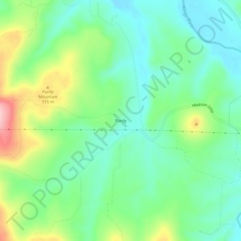
Name: Purdy topographic map, elevation, terrain.
Location: Purdy, Madison County, Arkansas, United States (36.07146 -93.59380 36.11146 -93.55380)
Average elevation: 450 m
Minimum elevation: 388 m
Maximum elevation: 584 m
Other topographic maps
Click on a map to view its topography, its elevation and its terrain.
Saint Paul
United States > Arkansas > Madison County
St. Paul is located in the Upper Boston Mountains ecoregion. The ecoregion is generally higher and moister than the Lower Boston Mountains; elevations vary from 1,900 to 2,800 feet (580 to 850 m). Potential natural vegetation is oak–hickory forest. Characteristically, the forests of the Upper Boston…
Average elevation: 529 m