Geolocate

Bletchingley topographic map

Click on the map to display elevation.

About this map

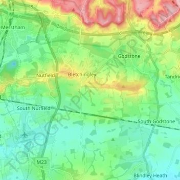
Name: Bletchingley topographic map, elevation, terrain.

Location: Bletchingley, Tandridge, Surrey, England, United Kingdom (51.19412 -0.13210 51.27256 -0.06834)

Average elevation: 106 m

Minimum elevation: 47 m

Maximum elevation: 250 m

Other topographic maps

Click on a map to view its topography, its elevation and its terrain.

Oak Cottages

United Kingdom > England > Surrey > Bletchingley

Average elevation: 103 m

Gear up for your next adventure:

🔦LED Flashlight - Powerful and long-lasting flashlight for camping and emergencies
🩹Moleskin Blister Pads - Direct protection for painful foot pressure points
🧥Insulated Jacket - Keep warm in cold outdoor conditions
🦶Hiking Shoe Insoles - Added support for high arches and long days on feet
🥾Waterproof Hiking Shoes - Durable shoes for wet and rugged trails

As an Amazon Associate, this site earns from qualifying purchases at no extra cost to you.