Geolocate

Carrascal topographic map

Click on the map to display elevation.

About this map

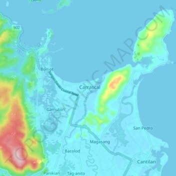
Name: Carrascal topographic map, elevation, terrain.

Location: Carrascal, Surigao del Sur, Caraga, 8317, Philippines (9.32884 125.90954 9.40884 125.98954)

Average elevation: 24 m

Minimum elevation: -1 m

Maximum elevation: 246 m

Other topographic maps

Click on a map to view its topography, its elevation and its terrain.

Bayabas

Philippines > Surigao del Sur

Average elevation: 35 m

Hinatuan

Philippines > Surigao del Sur

Average elevation: 30 m

Lingig

Philippines > Surigao del Sur

Average elevation: 70 m

Bislig

Philippines > Surigao del Sur

Average elevation: 71 m

Carac-an River

Philippines > Surigao del Sur > Cancavan

Average elevation: 23 m

Lingig

Philippines > Surigao del Sur

Average elevation: 70 m

Hinatuan

Philippines > Surigao del Sur

Average elevation: 30 m

Hinatuan

Philippines > Surigao del Sur

Average elevation: 30 m

Bislig

Philippines > Surigao del Sur

Average elevation: 71 m

Gear up for your next adventure:

🦟Insect Repellent - Keep mosquitoes and black flies away in wooded areas
🔪Outdoor Multitool - Versatile tool for repairs and food prep in the wild
👟Leg Gaiters - Keep debris, mud, and snow out of your boots
🥾Light Trekking Boots - Supportive boots for multi-day treks
🧭GPS Outdoor Watch - Smart watch for navigation and fitness tracking in nature

As an Amazon Associate, this site earns from qualifying purchases at no extra cost to you.