
Vilcas Huamán topographic map
Interactive map
Click on the map to display elevation.
About this map
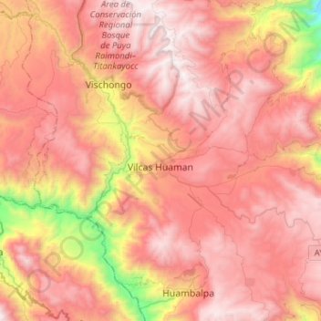
Name: Vilcas Huamán topographic map, elevation, terrain.
Location: Vilcas Huamán, Provincia de Vilcas Huamán, Ayacucho, Perú (-13.72134 -74.01156 -13.57470 -73.75665)
Average elevation: 3,518 m
Minimum elevation: 2,120 m
Maximum elevation: 4,335 m
Se encuentra ubicado a 117 km al sudeste de la ciudad de Ayacucho y a una altitud de 3470 msnm.
Other topographic maps
Click on a map to view its topography, its elevation and its terrain.
Apachita
Perú > Ayacucho > Vilcas Huaman > Alto Perú
Apachita, Alto Perú, Vilcas Huamán, Ayacucho, Perú
Average elevation: 3,500 m