Geolocate

Catalina topographic map

Click on the map to display elevation.

About this map

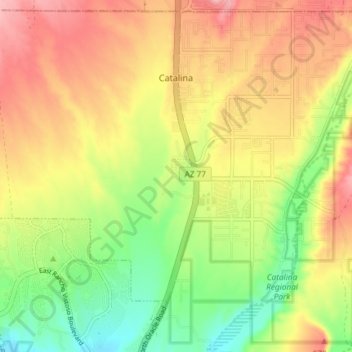
Name: Catalina topographic map, elevation, terrain.

Location: Catalina, Pima County, Arizona, United States (32.45268 -110.93563 32.51170 -110.86173)

Average elevation: 950 m

Minimum elevation: 868 m

Maximum elevation: 1,171 m

Gear up for your next adventure:

🦶Hiking Shoe Insoles - Added support for high arches and long days on feet
🧰Multitool Knife - Compact and versatile tool for outdoor use
🧭GPS Tracker - Track your location in remote areas safely
🧼Travel Hand Sanitizer - Keep hands clean when water is scarce
🧴Outdoor Sunscreen - High SPF protection for high-altitude UV exposure

As an Amazon Associate, this site earns from qualifying purchases at no extra cost to you.