
Make a donation
Gear up for your next adventure:
As an Amazon Associate, this site earns from qualifying purchases at no extra cost to you.
Milpitas topographic map
Click on the map to display elevation.
Make a donation
Gear up for your next adventure:
As an Amazon Associate, this site earns from qualifying purchases at no extra cost to you.
Milpitas
The median elevation of Milpitas is 19 feet (6 m). At Piedmont Road, Evans Road, and North Park Victoria Drive, the elevation is generally about 100 feet (30 m), while the western area is almost at sea level. The highest point in Milpitas is a 1,289-foot (393 m) peak in the southeastern foothills.
Make a donation
Gear up for your next adventure:
As an Amazon Associate, this site earns from qualifying purchases at no extra cost to you.
About this map
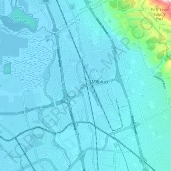
Name: Milpitas topographic map, elevation, terrain.
Average elevation: 47 m
Minimum elevation: -6 m
Maximum elevation: 585 m
Make a donation
Gear up for your next adventure:
As an Amazon Associate, this site earns from qualifying purchases at no extra cost to you.
Other topographic maps
Click on a map to view its topography, its elevation and its terrain.
Sunnyvale
United States > California > Santa Clara County > Sunnyvale
According to the United States Census Bureau, the city has a total area of 22.7 sq mi (58.8 km2), of which, 22.0 sq mi (56.9 km2) of it is land and 0.69 sq mi (1.8 km2) of it (3.09%) is water. Its elevation is 130 feet above sea level.
Average elevation: 150 m