Geolocate

Sunnyvale topographic map

Click on the map to display elevation.

Sunnyvale

According to the United States Census Bureau, the city has a total area of 22.7 sq mi (58.8 km2), of which, 22.0 sq mi (56.9 km2) of it is land and 0.69 sq mi (1.8 km2) of it (3.09%) is water. Its elevation is 130 feet above sea level.

About this map

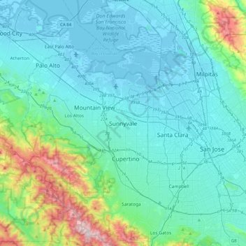
Name: Sunnyvale topographic map, elevation, terrain.

Location: Sunnyvale, Santa Clara County, California, 94807, United States (37.20883 -122.19635 37.52883 -121.87635)

Average elevation: 150 m

Minimum elevation: -6 m

Maximum elevation: 980 m

Gear up for your next adventure:

🥾Waterproof Hiking Boots - Essential footwear for rugged terrain and wet Canadian trails
🧴Insect Repellent - Protect yourself from bugs during outdoor adventures
🥾Light Hiking Boots - Lightweight and comfortable boots for day hikes
🍽️Titanium Camping Spork - Ultralight and indestructible eating utensil
👟Trail Running Shoes - Agile footwear for fast-paced topographic exploration

As an Amazon Associate, this site earns from qualifying purchases at no extra cost to you.