
Morrison Cove topographic map
Interactive map
Click on the map to display elevation.
About this map
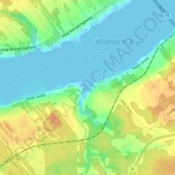
Name: Morrison Cove topographic map, elevation, terrain.
Average elevation: 16 m
Minimum elevation: -3 m
Maximum elevation: 36 m
Other topographic maps
Click on a map to view its topography, its elevation and its terrain.
French Fort Cove
Canada > New Brunswick > City of Miramichi > Miramichi
French Fort Cove, Newcastle, Miramichi, City of Miramichi, Northumberland County, New Brunswick, E1V 5L7, Canada
Average elevation: 32 m