Geolocate

Navarrenx topographic map

Click on the map to display elevation.

About this map

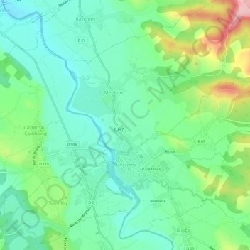
Name: Navarrenx topographic map, elevation, terrain.

Location: Navarrenx, Oloron-Sainte-Marie, Pyrénées-Atlantiques, Nouvelle-Aquitaine, Metropolitan France, 64190, France (43.30917 -0.76639 43.34899 -0.70618)

Average elevation: 145 m

Minimum elevation: 94 m

Maximum elevation: 265 m

Other topographic maps

Click on a map to view its topography, its elevation and its terrain.

Gabas

France > Nouvelle-Aquitaine > Pyrénées-Atlantiques > Laruns

Average elevation: 1,452 m

Pon

France > Nouvelle-Aquitaine > Pyrénées-Atlantiques > Laruns

Average elevation: 809 m

Gear up for your next adventure:

🛏️Sleeping Bag - Warm and compact sleeping bags for outdoor camping
🏕️Camping Hammock - Integrated protection for sleeping between trees
🧣Evaporative Cooling Towel - Beat the heat during intense summer climbs
🛶Waterproof Dry Bags - Keep electronics and clothes dry during river crossings
🧤Thermal Hiking Gloves - Grip-enhanced gloves for cold-weather altitude trekking

As an Amazon Associate, this site earns from qualifying purchases at no extra cost to you.