Geolocate

Carolina topographic map

Click on the map to display elevation.

About this map

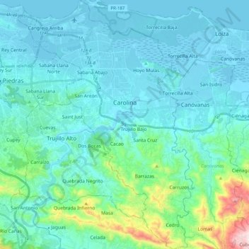
Name: Carolina topographic map, elevation, terrain.

Location: Carolina, Puerto Rico, United States (18.27005 -66.04310 18.45801 -65.90179)

Average elevation: 86 m

Minimum elevation: -3 m

Maximum elevation: 636 m

Other topographic maps

Click on a map to view its topography, its elevation and its terrain.

Toa Alta

United States > Puerto Rico > Toa Alta > Toa Alta

Average elevation: 60 m

Gear up for your next adventure:

🧥Waterproof Hiking Jacket - Protect yourself from rain and wind while hiking
🧢Outdoor Cap - Protective cap for sun and rain during hikes
🧰Emergency Multi-Tool - Compact multi-tool for outdoor survival
🥽Outdoor Goggles - Protective eyewear for outdoor activities
🥾Approach Shoes - Shoes designed for climbing approaches and rugged trails

As an Amazon Associate, this site earns from qualifying purchases at no extra cost to you.