
Slaidburn topographic map
Click on the map to display elevation.
About this map
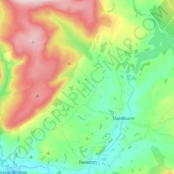
Name: Slaidburn topographic map, elevation, terrain.
Location: Slaidburn, Ribble Valley, Lancashire, England, United Kingdom (53.95181 -2.49995 54.00881 -2.37765)
Average elevation: 251 m
Minimum elevation: 113 m
Maximum elevation: 490 m
Other topographic maps
Click on a map to view its topography, its elevation and its terrain.
Billington and Langho
United Kingdom > England > Lancashire > Ribble Valley > Brockhall Village
Average elevation: 58 m
Old Langho
United Kingdom > England > Lancashire > Ribble Valley > Brockhall Village
Average elevation: 74 m
Brungerley Park
United Kingdom > England > Lancashire > Ribble Valley > Clitheroe > Waddington
Average elevation: 77 m
Mellor Brook
United Kingdom > England > Lancashire > Ribble Valley > Mellor Brook
Average elevation: 106 m