
Make a donation
Gear up for your next adventure:
As an Amazon Associate, this site earns from qualifying purchases at no extra cost to you.
San Sebastián topographic map
Click on the map to display elevation.
Make a donation
Gear up for your next adventure:
As an Amazon Associate, this site earns from qualifying purchases at no extra cost to you.
About this map
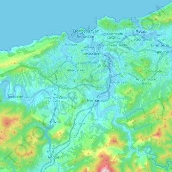
Name: San Sebastián topographic map, elevation, terrain.
Average elevation: 120 m
Minimum elevation: -2 m
Maximum elevation: 803 m
Make a donation
Gear up for your next adventure:
As an Amazon Associate, this site earns from qualifying purchases at no extra cost to you.
Other topographic maps
Click on a map to view its topography, its elevation and its terrain.
Marabi
Spain > Autonomous Community of the Basque Country > Amorebieta-Etxano
Average elevation: 161 m
Bujal
Spain > Autonomous Community of the Basque Country > Añanako kuadrilla > Berantevilla
Average elevation: 535 m
Make a donation
Gear up for your next adventure:
As an Amazon Associate, this site earns from qualifying purchases at no extra cost to you.
Gorbeia
Spain > Autonomous Community of the Basque Country > Gorbeialdea > Zeanuri
Average elevation: 1,189 m
Hondarribiko hondartza
Spain > Autonomous Community of the Basque Country > Gipuzkoako Bidasoa > Hondarribia
Average elevation: 31 m
Floreaga
Spain > Autonomous Community of the Basque Country > Urola-Kosta > Azkoitia
Average elevation: 266 m
Make a donation
Gear up for your next adventure:
As an Amazon Associate, this site earns from qualifying purchases at no extra cost to you.
Make a donation
Gear up for your next adventure:
As an Amazon Associate, this site earns from qualifying purchases at no extra cost to you.
Trevilla
Spain > Autonomous Community of the Basque Country > Karrantza Harana/Valle de Carranza > Concha
Average elevation: 333 m
Lore-Toki
Spain > Autonomous Community of the Basque Country > Arabako Errioxa/Rioja Alavesa > Labastida/Bastida
Average elevation: 499 m
Flysch
Spain > Autonomous Community of the Basque Country > Urola-Kosta > Zumaia
Average elevation: 27 m
Make a donation
Gear up for your next adventure:
As an Amazon Associate, this site earns from qualifying purchases at no extra cost to you.
Barinatxe - La Salvaje
Spain > Autonomous Community of the Basque Country > Sopela
Average elevation: 26 m
Torrea
Spain > Autonomous Community of the Basque Country > Debabarrena > Eibar
Average elevation: 398 m
Iruka
Spain > Autonomous Community of the Basque Country > Debabarrena > Eibar
Average elevation: 425 m
Make a donation
Gear up for your next adventure:
As an Amazon Associate, this site earns from qualifying purchases at no extra cost to you.
Fuente Oneri
Spain > Autonomous Community of the Basque Country > Arabako lautada/Llanada Alavesa > Agurain/Salvatierra
Average elevation: 681 m
Makola
Spain > Autonomous Community of the Basque Country > Urola-Kosta > Azkoitia
Average elevation: 515 m
Soil
Spain > Autonomous Community of the Basque Country > Montaña Alavesa/Arabako Mendialdea
Average elevation: 898 m
Make a donation
Gear up for your next adventure:
As an Amazon Associate, this site earns from qualifying purchases at no extra cost to you.
Gebara
Spain > Autonomous Community of the Basque Country > Arabako lautada/Llanada Alavesa
Average elevation: 574 m
Santa Barbara
Spain > Autonomous Community of the Basque Country > Hernani > Sorgintxulo
Average elevation: 68 m
Make a donation
Gear up for your next adventure:
As an Amazon Associate, this site earns from qualifying purchases at no extra cost to you.
Karakate
Spain > Autonomous Community of the Basque Country > Debabarrena > Soraluze
Average elevation: 366 m
Monterredondo
Spain > Autonomous Community of the Basque Country > Añanako kuadrilla/Cuadrilla de Añana
Average elevation: 875 m
Araneta
Spain > Autonomous Community of the Basque Country > Gasteizko kuadrilla/Cuadrilla de Vitoria > Vitoria-Gasteiz > Bolívar
Average elevation: 625 m
Make a donation
Gear up for your next adventure:
As an Amazon Associate, this site earns from qualifying purchases at no extra cost to you.
Gautegiz Arteaga
Spain > Autonomous Community of the Basque Country > Gautegiz Arteaga > Gautegiz Arteaga
Average elevation: 104 m
Oñati
Spain > Autonomous Community of the Basque Country > Debagoiena > Oñati
Average elevation: 488 m
Zaldibar
Spain > Autonomous Community of the Basque Country > Zaldibar > Zaldibar
Average elevation: 305 m
Make a donation
Gear up for your next adventure:
As an Amazon Associate, this site earns from qualifying purchases at no extra cost to you.
Soil
Spain > Autonomous Community of the Basque Country > Montaña Alavesa/Arabako Mendialdea
Average elevation: 898 m
Plaza de Larrazábal
Spain > Autonomous Community of the Basque Country > Bilbao
Average elevation: 101 m