Geolocate

Gebara topographic map

Click on the map to display elevation.

About this map

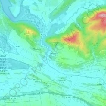
Name: Gebara topographic map, elevation, terrain.

Location: Gebara, Barrundia, Arabako lautada/Llanada Alavesa, Álava, Autonomous Community of the Basque Country, 01206, Spain (42.87414 -2.53072 42.91414 -2.49072)

Average elevation: 574 m

Minimum elevation: 534 m

Maximum elevation: 737 m

Other topographic maps

Click on a map to view its topography, its elevation and its terrain.

Gear up for your next adventure:

🔭Compact Binoculars - Lightweight optics for scouting trails and wildlife
🕶️Polarized Sunglasses - Protect your eyes with durable polarized lenses
👟Leg Gaiters - Keep debris, mud, and snow out of your boots
🥾Trail Hiking Shoes - Durable shoes designed for rugged trails
🥾Approach Boots - Comfortable boots for hiking and climbing approaches

As an Amazon Associate, this site earns from qualifying purchases at no extra cost to you.