
Make a donation
Gear up for your next adventure:
As an Amazon Associate, this site earns from qualifying purchases at no extra cost to you.
Körperich topographic map
Click on the map to display elevation.
Make a donation
Gear up for your next adventure:
As an Amazon Associate, this site earns from qualifying purchases at no extra cost to you.
About this map
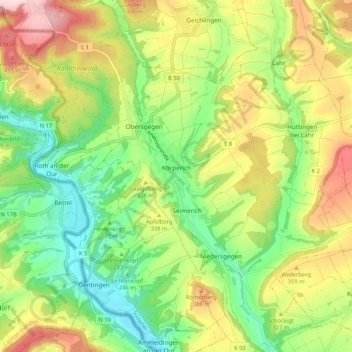
Name: Körperich topographic map, elevation, terrain.
Average elevation: 308 m
Minimum elevation: 182 m
Maximum elevation: 486 m
Make a donation
Gear up for your next adventure:
As an Amazon Associate, this site earns from qualifying purchases at no extra cost to you.
Other topographic maps
Click on a map to view its topography, its elevation and its terrain.
Krummenacker
Deutschland > Rheinland-Pfalz > Eifelkreis Bitburg-Prüm > Plütscheid
Average elevation: 497 m
Make a donation
Gear up for your next adventure:
As an Amazon Associate, this site earns from qualifying purchases at no extra cost to you.
Dickenberg
Deutschland > Rheinland-Pfalz > Eifelkreis Bitburg-Prüm > Gondenbrett
Average elevation: 517 m
Buscht
Deutschland > Rheinland-Pfalz > Eifelkreis Bitburg-Prüm
Der Ortsteil Buscht liegt südlich der Ortsgemeinde Utscheid auf einer Anhöhe. Der ältere Teil des Ortes ist durch steile Hanglage geprägt, während sich Neubauten auf der sich anschließenden Hochebene befinden. Buscht ist zudem von umfangreichen Waldbeständen umgeben.
Average elevation: 376 m
Schwarzer Mann
Deutschland > Rheinland-Pfalz > Eifelkreis Bitburg-Prüm > Buchet
Der Schwarze Mann bei Buchet-Halenfeld im rheinland-pfälzischen Eifelkreis Bitburg-Prüm ist mit 697,8 m ü. NHN nach einem nahen Gipfel mit 699,1 m Höhe die zweithöchste Erhebung der Schneifel.
Average elevation: 621 m
Bellscheid
Deutschland > Rheinland-Pfalz > Eifelkreis Bitburg-Prüm > Krautscheid
Average elevation: 471 m
Make a donation
Gear up for your next adventure:
As an Amazon Associate, this site earns from qualifying purchases at no extra cost to you.
Laudesfeld
Deutschland > Rheinland-Pfalz > Eifelkreis Bitburg-Prüm > Auw bei Prüm
Average elevation: 526 m
Make a donation
Gear up for your next adventure:
As an Amazon Associate, this site earns from qualifying purchases at no extra cost to you.
Hinterer Essebach
Deutschland > Rheinland-Pfalz > Eifelkreis Bitburg-Prüm > Menningen
Average elevation: 288 m
Ringelstein
Deutschland > Rheinland-Pfalz > Eifelkreis Bitburg-Prüm > Biersdorf am See
Average elevation: 349 m
Heckhalenfeld
Deutschland > Rheinland-Pfalz > Eifelkreis Bitburg-Prüm > Winterspelt
Average elevation: 480 m
Make a donation
Gear up for your next adventure:
As an Amazon Associate, this site earns from qualifying purchases at no extra cost to you.
Gesotz
Deutschland > Rheinland-Pfalz > Eifelkreis Bitburg-Prüm > Lascheid
Sehenswert ist in Gesotz eine ca. 200 Jahre alte Roteiche mit einer Höhe von rund 20 m. Der Baum gehört als Naturdenkmal zur Ortsgemeinde Lascheid.
Average elevation: 499 m
Make a donation
Gear up for your next adventure:
As an Amazon Associate, this site earns from qualifying purchases at no extra cost to you.