
Thank you for supporting this site ❤️
Make a donation
Make a donation
Gear up for your next adventure:
As an Amazon Associate, this site earns from qualifying purchases at no extra cost to you.
Schwarzer Mann topographic map
Click on the map to display elevation.
Thank you for supporting this site ❤️
Make a donation
Make a donation
Gear up for your next adventure:
As an Amazon Associate, this site earns from qualifying purchases at no extra cost to you.
Schwarzer Mann
Der Schwarze Mann bei Buchet-Halenfeld im rheinland-pfälzischen Eifelkreis Bitburg-Prüm ist mit 697,8 m ü. NHN nach einem nahen Gipfel mit 699,1 m Höhe die zweithöchste Erhebung der Schneifel.
Thank you for supporting this site ❤️
Make a donation
Make a donation
Gear up for your next adventure:
As an Amazon Associate, this site earns from qualifying purchases at no extra cost to you.
About this map
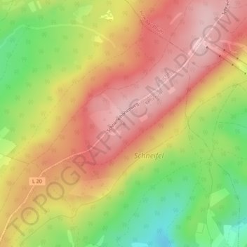
Name: Schwarzer Mann topographic map, elevation, terrain.
Average elevation: 621 m
Minimum elevation: 510 m
Maximum elevation: 702 m
Thank you for supporting this site ❤️
Make a donation
Make a donation
Gear up for your next adventure:
As an Amazon Associate, this site earns from qualifying purchases at no extra cost to you.