Geolocate

Bristow topographic map

Click on the map to display elevation.

About this map

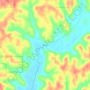
Name: Bristow topographic map, elevation, terrain.

Location: Bristow, Perry County, Indiana, United States (38.12006 -86.74166 38.16006 -86.70166)

Average elevation: 157 m

Minimum elevation: 122 m

Maximum elevation: 199 m

Other topographic maps

Click on a map to view its topography, its elevation and its terrain.

Tell City

United States > Indiana > Perry County

Average elevation: 130 m

Tell City

United States > Indiana > Perry County

Average elevation: 130 m

Gear up for your next adventure:

🧰Survival Kit - Essential gear for emergencies in the wilderness
🧼Travel Hand Sanitizer - Keep hands clean when water is scarce
🧣Evaporative Cooling Towel - Beat the heat during intense summer climbs
🚲Heavy Duty Bike Lock - Secure your bike at the trailhead or during stops
Camping Tent - Weather-resistant tents suitable for 2 to 6 people

As an Amazon Associate, this site earns from qualifying purchases at no extra cost to you.