Geolocate

Cannelton topographic map

Click on the map to display elevation.

About this map

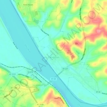
Name: Cannelton topographic map, elevation, terrain.

Location: Cannelton, Perry County, Indiana, United States (37.89378 -86.75478 37.93191 -86.70316)

Average elevation: 139 m

Minimum elevation: 107 m

Maximum elevation: 206 m

Other topographic maps

Click on a map to view its topography, its elevation and its terrain.

Fenn Haven

United States > Indiana > Perry County > Tell City

Average elevation: 137 m

Branchville

United States > Indiana > Perry County

Average elevation: 180 m

Gerald

United States > Indiana > Perry County

Average elevation: 160 m

Gear up for your next adventure:

🧼Travel Hand Sanitizer - Keep hands clean when water is scarce
🧥Thermal Layer - Insulating layer for cold outdoor conditions
🧥Thermal Fleece Jacket - Versatile insulation for changing mountain temperatures
💧Filtered Water Bottle - Safe drinking water on the go
🛏️Camping Sleeping Mat - Comfortable mats for sleeping outdoors

As an Amazon Associate, this site earns from qualifying purchases at no extra cost to you.