
Make a donation
Gear up for your next adventure:
As an Amazon Associate, this site earns from qualifying purchases at no extra cost to you.
Whitecourt topographic map
Click on the map to display elevation.
Make a donation
Gear up for your next adventure:
As an Amazon Associate, this site earns from qualifying purchases at no extra cost to you.
Whitecourt
Whitecourt is a town in central Alberta, Canada within Woodlands County. It is located approximately 177 km (110 mi) northwest of Edmonton and 279 km (173 mi) southeast of Grande Prairie at the junction of Highway 43 and Highway 32, and has an elevation of 690 m (2,260 ft). The Whitecourt meteor impact crater is found on nearby Whitecourt Mountain.
Make a donation
Gear up for your next adventure:
As an Amazon Associate, this site earns from qualifying purchases at no extra cost to you.
About this map
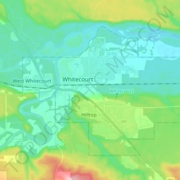
Name: Whitecourt topographic map, elevation, terrain.
Location: Whitecourt, Alberta, T7S 1M4, Canada (54.09761 -115.71512 54.17761 -115.63512)
Average elevation: 721 m
Minimum elevation: 677 m
Maximum elevation: 863 m
Alberta trails, hiking, mountain biking, running and outdoor activities
Make a donation
Gear up for your next adventure:
As an Amazon Associate, this site earns from qualifying purchases at no extra cost to you.