Geolocate

Kungsberget topographic map

Click on the map to display elevation.

About this map

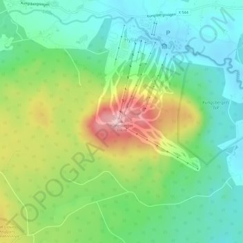
Name: Kungsberget topographic map, elevation, terrain.

Location: Kungsberget, Sandvikens kommun, Gävleborg County, Sweden (60.75023 16.49105 60.75033 16.49115)

Average elevation: 179 m

Minimum elevation: 113 m

Maximum elevation: 307 m

Other topographic maps

Click on a map to view its topography, its elevation and its terrain.

Gävle

Sweden > Gävleborg County

Average elevation: 28 m

Disan

Sweden > Gävleborg County

Average elevation: 43 m

Gran

Sweden > Gävleborg County > Gnarp District

Average elevation: 0 m

Ljusdals kommun

Sweden > Gävleborg County

Average elevation: 315 m

Hamra

Sweden > Gävleborg County

Average elevation: 437 m

Hamra

Sweden > Gävleborg County

Average elevation: 437 m

Hudiksvalls kommun

Sweden > Gävleborg County

Average elevation: 95 m

Hamra

Sweden > Gävleborg County

Average elevation: 437 m

Söderhamns kommun

Sweden > Gävleborg County

Average elevation: 67 m

Gnarp District

Sweden > Gävleborg County

Average elevation: 32 m

Gävle kommun

Sweden > Gävleborg County

Average elevation: 61 m

Ovanåkers kommun

Sweden > Gävleborg County

Average elevation: 269 m

Hofors kommun

Sweden > Gävleborg County

Average elevation: 147 m

Gear up for your next adventure:

🛶Kayak Dry Bag - Waterproof storage for kayaking adventures
🦶Hiking Shoe Insoles - Added support for high arches and long days on feet
🕶️Polarized Sunglasses - Reduces glare from snow and water at high elevations
🛏️Camping Sleeping Mat - Comfortable mats for sleeping outdoors
💡Portable Camping Lamp - Rechargeable lamp for campsite lighting

As an Amazon Associate, this site earns from qualifying purchases at no extra cost to you.