Geolocate

Rinconada topographic map

Click on the map to display elevation.

About this map

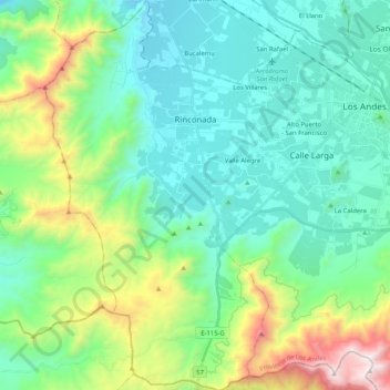
Name: Rinconada topographic map, elevation, terrain.

Location: Rinconada, Provincia de Los Andes, Valparaiso Region, Chile (-32.95919 -70.76690 -32.78686 -70.64871)

Average elevation: 1,058 m

Minimum elevation: 678 m

Maximum elevation: 2,286 m

Other topographic maps

Click on a map to view its topography, its elevation and its terrain.

Gear up for your next adventure:

🧊Insulated Water Bottle - Keeps drinks cold in summer and prevents freezing in winter
🧥Waterproof Hiking Jacket - Protect yourself from rain and wind while hiking
🥾Approach Shoes - Shoes designed for climbing approaches and rugged trails
🧴Bear Spray Holster - Quick-access carry for essential Canadian wilderness safety
🧤Rechargeable Heated Gloves - Extreme warmth for Canadian winter expeditions

As an Amazon Associate, this site earns from qualifying purchases at no extra cost to you.