
Make a donation
Gear up for your next adventure:
As an Amazon Associate, this site earns from qualifying purchases at no extra cost to you.
Zlatibor topographic map
Click on the map to display elevation.
Make a donation
Gear up for your next adventure:
As an Amazon Associate, this site earns from qualifying purchases at no extra cost to you.
Zlatibor
Zlatibor itself is located in the northern part of the Stari Vlah region, a historical border region between Raška, Herzegovina and Bosnia. It spreads over an area of 300 km2 (120 sq mi), 43 km (27 mi) in length, southeast to northwest, and up to 37 km (23 mi) in width. Its highest peak, Tornik, has an elevation of 1,496 m. Zlatibor is situated between 43° 31' N, and 43° 51' N, and between 19° 28' E and 19° 56' E.
Make a donation
Gear up for your next adventure:
As an Amazon Associate, this site earns from qualifying purchases at no extra cost to you.
About this map
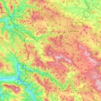
Name: Zlatibor topographic map, elevation, terrain.
Average elevation: 876 m
Minimum elevation: 370 m
Maximum elevation: 1,487 m
Make a donation
Gear up for your next adventure:
As an Amazon Associate, this site earns from qualifying purchases at no extra cost to you.
Other topographic maps
Click on a map to view its topography, its elevation and its terrain.
Валеница
Serbia > Zlatibor Administrative District > Prijepolje Municipality
Average elevation: 1,474 m
Mali Povlen
Serbia > Zlatibor Administrative District > Kosjeric Municipality
Average elevation: 1,139 m
Make a donation
Gear up for your next adventure:
As an Amazon Associate, this site earns from qualifying purchases at no extra cost to you.
Валеница
Serbia > Zlatibor Administrative District > Prijepolje Municipality
Average elevation: 1,474 m