
Make a donation
Gear up for your next adventure:
As an Amazon Associate, this site earns from qualifying purchases at no extra cost to you.
Mali Povlen topographic map
Click on the map to display elevation.
Make a donation
Gear up for your next adventure:
As an Amazon Associate, this site earns from qualifying purchases at no extra cost to you.
About this map
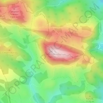
Name: Mali Povlen topographic map, elevation, terrain.
Average elevation: 1,139 m
Minimum elevation: 968 m
Maximum elevation: 1,338 m
Make a donation
Gear up for your next adventure:
As an Amazon Associate, this site earns from qualifying purchases at no extra cost to you.
Other topographic maps
Click on a map to view its topography, its elevation and its terrain.
Gornja Polosnica
Serbia > Zlatibor Administrative District > Kosjeric Municipality
Average elevation: 655 m
Make a donation
Gear up for your next adventure:
As an Amazon Associate, this site earns from qualifying purchases at no extra cost to you.
Kosjerić (town)
Serbia > Zlatibor Administrative District > Kosjeric Municipality
Kosjeríć (Serbian Cyrillic: Косјерић, pronounced [kɔsjɛ̌rit͡ɕ]) is a town and municipality located in the Zlatibor District of western Serbia. The municipality has a population of 10,175 inhabitants and the town itself has 3,723 (2022 census). The municipality's area is 359 square kilometres…
Average elevation: 465 m