Geolocate

Centre topographic map

Click on the map to display elevation.

About this map

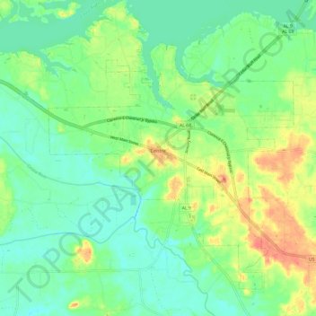
Name: Centre topographic map, elevation, terrain.

Location: Centre, Cherokee County, Alabama, United States (34.10890 -85.74657 34.19043 -85.62799)

Average elevation: 177 m

Minimum elevation: 157 m

Maximum elevation: 213 m

Other topographic maps

Click on a map to view its topography, its elevation and its terrain.

Taft

United States > Alabama > Cherokee County

Average elevation: 275 m

Gear up for your next adventure:

🥫Freeze-Dried Meals - Lightweight, high-calorie nutrition for multi-day treks
🧳Compression Sacks - Maximize space in your backpack by shrinking gear
🥾Trail Running Shoes - Lightweight and durable shoes for trail running
🛏️Camping Sleeping Mat - Comfortable mats for sleeping outdoors
🧤Insulated Winter Gloves - Heavy-duty protection for sub-zero Canadian adventures

As an Amazon Associate, this site earns from qualifying purchases at no extra cost to you.