
Make a donation
Gear up for your next adventure:
As an Amazon Associate, this site earns from qualifying purchases at no extra cost to you.
Quirnheim topographic map
Click on the map to display elevation.
Make a donation
Gear up for your next adventure:
As an Amazon Associate, this site earns from qualifying purchases at no extra cost to you.
About this map
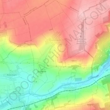
Name: Quirnheim topographic map, elevation, terrain.
Average elevation: 243 m
Minimum elevation: 148 m
Maximum elevation: 318 m
Make a donation
Gear up for your next adventure:
As an Amazon Associate, this site earns from qualifying purchases at no extra cost to you.
Other topographic maps
Click on a map to view its topography, its elevation and its terrain.
Rheinebene
Deutschland > Rheinland-Pfalz > Landkreis Bad Dürkheim > Weisenheim am Berg
Average elevation: 238 m
Make a donation
Gear up for your next adventure:
As an Amazon Associate, this site earns from qualifying purchases at no extra cost to you.
Hornesselwiese
Deutschland > Rheinland-Pfalz > Landkreis Bad Dürkheim > Elmstein
Average elevation: 372 m
Speyerbrunn
Deutschland > Rheinland-Pfalz > Landkreis Bad Dürkheim > Elmstein
Average elevation: 426 m
Isenach Ursprung
Deutschland > Rheinland-Pfalz > Landkreis Bad Dürkheim > Wattenheim
Average elevation: 370 m
Klosterruine Limburg
Deutschland > Rheinland-Pfalz > Landkreis Bad Dürkheim > Bad Dürkheim
Die Klosterruine Limburg liegt im Naturpark Pfälzerwald exponiert über dem Südufer eines linken Rhein-Nebenflusses, der Isenach, die im Westen von Bad Dürkheim die Haardt, den Ostrand des Pfälzerwalds, durchbricht und durch das schmale Hügelland an der Deutschen Weinstraße in die Rheinebene eintritt.…
Average elevation: 227 m
Make a donation
Gear up for your next adventure:
As an Amazon Associate, this site earns from qualifying purchases at no extra cost to you.
Krumbachtal
Deutschland > Rheinland-Pfalz > Landkreis Bad Dürkheim > Battenberg (Pfalz)
Average elevation: 333 m
Kleiner Peterskopf
Deutschland > Rheinland-Pfalz > Landkreis Bad Dürkheim > Bad Dürkheim
Average elevation: 308 m
Hertlingshausen
Deutschland > Rheinland-Pfalz > Landkreis Bad Dürkheim
Der Ortsteil liegt auf etwa 300 m Höhe im nordöstlichen Pfälzerwald. Er wird vom Eckbach durchflossen, der im westlichen Gemarkungsteil Kleinfrankreich entspringt. Da die Gemeinde Carlsberg eine Streusiedlung bildet, ist eine räumliche Trennung zwischen dem Kernort Carlsberg und Hertlingshausen nicht…
Average elevation: 331 m
Make a donation
Gear up for your next adventure:
As an Amazon Associate, this site earns from qualifying purchases at no extra cost to you.
Elsa Host-Brunnen
Deutschland > Rheinland-Pfalz > Landkreis Bad Dürkheim > Weidenthal
Average elevation: 326 m
Mollenkopf
Deutschland > Rheinland-Pfalz > Landkreis Bad Dürkheim > Weidenthal
Average elevation: 393 m
Schwabenbach
Deutschland > Rheinland-Pfalz > Landkreis Bad Dürkheim > Elmstein
Average elevation: 365 m