
Make a donation
Gear up for your next adventure:
As an Amazon Associate, this site earns from qualifying purchases at no extra cost to you.
Kleiner Peterskopf topographic map
Click on the map to display elevation.
Make a donation
Gear up for your next adventure:
As an Amazon Associate, this site earns from qualifying purchases at no extra cost to you.
About this map
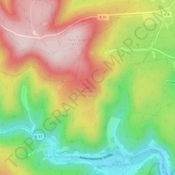
Name: Kleiner Peterskopf topographic map, elevation, terrain.
Average elevation: 308 m
Minimum elevation: 131 m
Maximum elevation: 487 m
Make a donation
Gear up for your next adventure:
As an Amazon Associate, this site earns from qualifying purchases at no extra cost to you.
Other topographic maps
Click on a map to view its topography, its elevation and its terrain.
Klosterruine Limburg
Deutschland > Rheinland-Pfalz > Landkreis Bad Dürkheim > Bad Dürkheim
Die Klosterruine Limburg liegt im Naturpark Pfälzerwald exponiert über dem Südufer eines linken Rhein-Nebenflusses, der Isenach, die im Westen von Bad Dürkheim die Haardt, den Ostrand des Pfälzerwalds, durchbricht und durch das schmale Hügelland an der Deutschen Weinstraße in die Rheinebene eintritt.…
Average elevation: 227 m