
Make a donation
Gear up for your next adventure:
As an Amazon Associate, this site earns from qualifying purchases at no extra cost to you.
Towanda topographic map
Click on the map to display elevation.
Make a donation
Gear up for your next adventure:
As an Amazon Associate, this site earns from qualifying purchases at no extra cost to you.
About this map
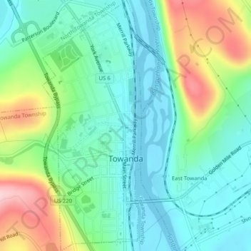
Name: Towanda topographic map, elevation, terrain.
Location: Towanda, Bradford County, Pennsylvania, United States (41.75661 -76.45593 41.78575 -76.44047)
Average elevation: 278 m
Minimum elevation: 211 m
Maximum elevation: 434 m
Make a donation
Gear up for your next adventure:
As an Amazon Associate, this site earns from qualifying purchases at no extra cost to you.
Other topographic maps
Click on a map to view its topography, its elevation and its terrain.
East Smithfield
United States > Pennsylvania > Bradford County > Smithfield Township
Average elevation: 416 m
Lake Wesauking
United States > Pennsylvania > Bradford County > Wysox Township
Average elevation: 355 m
Windham Summit
United States > Pennsylvania > Bradford County > Windham Township
Average elevation: 430 m
Make a donation
Gear up for your next adventure:
As an Amazon Associate, this site earns from qualifying purchases at no extra cost to you.
Columbia Cross Roads
United States > Pennsylvania > Bradford County > Columbia Township
Average elevation: 411 m
Make a donation
Gear up for your next adventure:
As an Amazon Associate, this site earns from qualifying purchases at no extra cost to you.
Gillett
United States > Pennsylvania > Bradford County > South Creek Township
Average elevation: 470 m
Granville Summit
United States > Pennsylvania > Bradford County > Granville Township
Average elevation: 448 m
Make a donation
Gear up for your next adventure:
As an Amazon Associate, this site earns from qualifying purchases at no extra cost to you.
Sheshequin
United States > Pennsylvania > Bradford County > Sheshequin Township
Average elevation: 310 m
Stevensville
United States > Pennsylvania > Bradford County > Stevens Township
Average elevation: 328 m
Warren Center
United States > Pennsylvania > Bradford County > Warren Township
Average elevation: 474 m
Make a donation
Gear up for your next adventure:
As an Amazon Associate, this site earns from qualifying purchases at no extra cost to you.
Make a donation
Gear up for your next adventure:
As an Amazon Associate, this site earns from qualifying purchases at no extra cost to you.
Make a donation
Gear up for your next adventure:
As an Amazon Associate, this site earns from qualifying purchases at no extra cost to you.