
Grand Lake topographic map
Click on the map to display elevation.
About this map
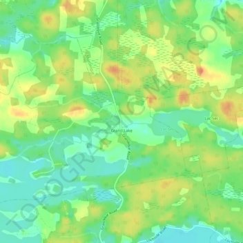
Name: Grand Lake topographic map, elevation, terrain.
Average elevation: 18 m
Minimum elevation: 0 m
Maximum elevation: 38 m
Other topographic maps
Click on a map to view its topography, its elevation and its terrain.
Barachois Pond
Canada > Nova Scotia > Municipality of the County of Richmond > Arichat
Average elevation: 16 m
Sampson Lake
Canada > Nova Scotia > Municipality of the County of Richmond > Louisdale
Average elevation: 7 m
Crow Island
Canada > Nova Scotia > Municipality of the County of Richmond > Poulamon
Average elevation: 40 m
Sporting Mountain
Canada > Nova Scotia > Municipality of the County of Richmond > River Bourgeois
Average elevation: 59 m
Garrets Lake
Canada > Nova Scotia > Municipality of the County of Richmond > Salmon River
Average elevation: 48 m
Comeau Point
Canada > Nova Scotia > Municipality of the County of Richmond > Alderney Point
Average elevation: 11 m