
Wollaston topographic map
Click on the map to display elevation.
About this map
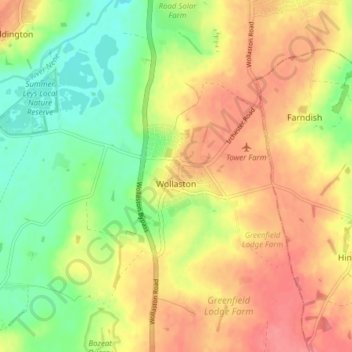
Name: Wollaston topographic map, elevation, terrain.
Location: Wollaston, North Northamptonshire, England, United Kingdom (52.23327 -0.72001 52.27744 -0.64277)
Average elevation: 72 m
Minimum elevation: 35 m
Maximum elevation: 105 m
Other topographic maps
Click on a map to view its topography, its elevation and its terrain.
Irchester Country Park
United Kingdom > England > North Northamptonshire > Little Irchester
Average elevation: 60 m
River Nene Navigation
United Kingdom > England > North Northamptonshire > Irchester
Average elevation: 55 m