
Halifax topographic map
Click on the map to display elevation.
About this map
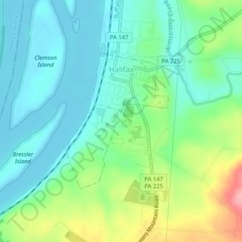
Name: Halifax topographic map, elevation, terrain.
Location: Halifax, Dauphin County, Pennsylvania, United States (40.45575 -76.93974 40.47094 -76.92454)
Average elevation: 144 m
Minimum elevation: 106 m
Maximum elevation: 239 m
Other topographic maps
Click on a map to view its topography, its elevation and its terrain.
Fort Hunter
United States > Pennsylvania > Dauphin County > Middle Paxton Township
Average elevation: 149 m
Reservoir Heights
United States > Pennsylvania > Dauphin County > Upper Paxton Township
Average elevation: 189 m
Blue Mountain
United States > Pennsylvania > Dauphin County > Middle Paxton Township
The ridge of Blue Mountain runs for 150 miles (240 km) through Pennsylvania, reaching an elevation of 2,270 feet (690 m) above sea level just north of the Pennsylvania Turnpike, near the borough of Newburg. Most of the ridgecrest, however, only reaches between 1,400 and 1,700 feet (430 and 520 m) in elevation.…
Average elevation: 199 m
Susquehanna River
United States > Pennsylvania > Dauphin County > Middle Paxton Township
Average elevation: 118 m
Manor Acres
United States > Pennsylvania > Dauphin County > West Hanover Township > Skyline View
Average elevation: 149 m
Susquehanna River
United States > Pennsylvania > Dauphin County > Susquehanna Township > Montrose Park
Average elevation: 114 m
Fort Hunter
United States > Pennsylvania > Dauphin County > Middle Paxton Township
Average elevation: 149 m
Pine Acres
United States > Pennsylvania > Dauphin County > West Hanover Township > Skyline View
Average elevation: 148 m
Mauntain View Lake
United States > Pennsylvania > Dauphin County > Halifax Township
Average elevation: 207 m