Geolocate

East Garo Hills topographic map

Interactive map

Click on the map to display elevation.

About this map

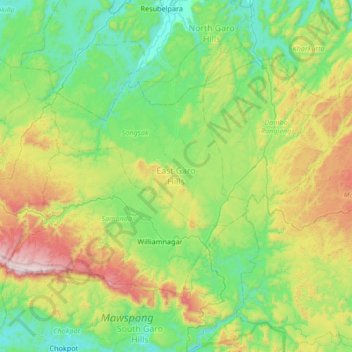
Name: East Garo Hills topographic map, elevation, terrain.

Location: East Garo Hills, Meghalaya, 783122, Inde (25.41575 90.31611 25.81983 90.98234)

Average elevation: 389 m

Minimum elevation: 27 m

Maximum elevation: 1,400 m

Other topographic maps

Click on a map to view its topography, its elevation and its terrain.

Mawsynram

Inde > Meghalaya > Mawsynram

Mawsynram, East Khasi Hills, Meghalaya, Inde

Average elevation: 1,107 m

Umling

Inde > Meghalaya > Umling

Umling, Ri-Bhoi, Meghalaya, Inde

Average elevation: 472 m

West Jaintia Hills

Inde > Meghalaya

West Jaintia Hills, Meghalaya, Inde

Average elevation: 933 m

Nongriat

Inde > Meghalaya > Nongriat

Nongriat, Shella Bholaganj, East Khasi Hills, Meghalaya, 793015, Inde

Average elevation: 706 m

Jaintia Hills

Inde > Meghalaya

Jaintia Hills, West Jaintia Hills District, Meghalaya, Inde

Average elevation: 534 m