Geolocate

Paud topographic map

Click on the map to display elevation.

About this map

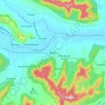
Name: Paud topographic map, elevation, terrain.

Location: Paud, Mulshi, Pune District, Maharashtra, 412108, India (18.48427 73.57551 18.56427 73.65551)

Average elevation: 660 m

Minimum elevation: 561 m

Maximum elevation: 976 m

Other topographic maps

Click on a map to view its topography, its elevation and its terrain.

Aamby Valley

India > Maharashtra > Mulshi

Average elevation: 710 m

Manas Lake

India > Maharashtra > Mulshi > Bhukum

Average elevation: 703 m

Mulshi Lake

India > Maharashtra > Mulshi > Chachivali

Average elevation: 710 m

Katarkhadak

India > Maharashtra > Mulshi

Average elevation: 810 m

Mula

India > Maharashtra > Mulshi

Average elevation: 658 m

Kasarsai

India > Maharashtra > Mulshi > Nere

Average elevation: 605 m

Gear up for your next adventure:

🛶Kayak Accessories - Essential gear for safe and fun kayaking adventures
Camping Groundsheet - Protect your tent from moisture and dirt
🥾Trail Hiking Socks - Comfortable socks to prevent blisters and fatigue
🚲Handlebar Phone Mount - View topographic-map.com live while cycling
🥾Hiking Boots - Sturdy boots providing ankle support and traction on rugged trails

As an Amazon Associate, this site earns from qualifying purchases at no extra cost to you.