
Make a donation
Gear up for your next adventure:
As an Amazon Associate, this site earns from qualifying purchases at no extra cost to you.
Stansbury Park topographic map
Click on the map to display elevation.
Make a donation
Gear up for your next adventure:
As an Amazon Associate, this site earns from qualifying purchases at no extra cost to you.
About this map
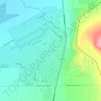
Name: Stansbury Park topographic map, elevation, terrain.
Location: Stansbury Park, Tooele County, Utah, 84407, United States (40.61772 -112.31606 40.65772 -112.27606)
Average elevation: 1,325 m
Minimum elevation: 1,288 m
Maximum elevation: 1,445 m
Make a donation
Gear up for your next adventure:
As an Amazon Associate, this site earns from qualifying purchases at no extra cost to you.
Other topographic maps
Click on a map to view its topography, its elevation and its terrain.
Make a donation
Gear up for your next adventure:
As an Amazon Associate, this site earns from qualifying purchases at no extra cost to you.
Lake Point
United States > Utah > Tooele County
John C. Frémont, a second lieutenant in the U.S. Army Corps of Topographical Engineers, was commissioned by the US Government to explore the Mexican territory west of the Louisiana Purchase with a special interest in the terrain and various routes that could link the Midwest to California. In the summer of…
Average elevation: 1,425 m