Geolocate

Otterbourne topographic map

Click on the map to display elevation.

About this map

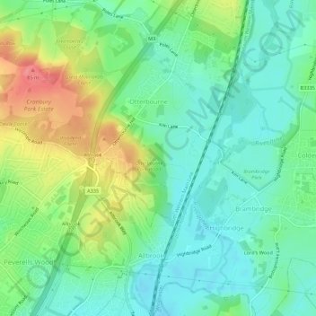
Name: Otterbourne topographic map, elevation, terrain.

Location: Otterbourne, Winchester, Hampshire, England, United Kingdom (50.98135 -1.36398 51.01561 -1.32419)

Average elevation: 38 m

Minimum elevation: 10 m

Maximum elevation: 94 m

Gear up for your next adventure:

Family Camping Tent - Spacious tent suitable for family camping trips
🥘Camping Cookware Set - Compact nesting pots and pans for trail cooking
🧢Outdoor Cap - Protective cap for sun and rain during hikes
Camping Coffee Maker - Brew fresh coffee anywhere on the topographic map
🛶Kayak Accessories - Essential gear for safe and fun kayaking adventures

As an Amazon Associate, this site earns from qualifying purchases at no extra cost to you.